Tools we develop
We develop a range of science-based tools for spatial planning and oceanographic analysis.
Shiny App: Migratory Connectivity in the Ocean (MiCO)
 Advancements in animal tracking technology are enabling far greater data collection on migration patterns than ever before. These data continue to broaden our understanding of the connectivity generated by migratory marine species—the critical habitats they depend on throughout their life cycles, and the pathways between them.
However, while the amount of data continues to grow exponentially, efforts to synthesize and provide access to information on migratory connectivity for management and policy has lagged behind. By transforming these data into actionable knowledge using MiCO, it can more effectively be incorporated into international management and policy frameworks to aid in the conservation and sustainable use of migratory species.
The MiCO App allows the user to access synthesized tracking data for over 100 migratory marine species, including sea turtles, seabirds, marine mammals, and fish. You can view migration routes, breeding sites, feeding areas, and corridors connecting critical habitats across ocean basins. MiCO bridges the current knowledge gap between science and policy by aggregating and producing actionable knowledge that can be directly used by managers and policy makers, as well as informing future research needs.
Shiny App: Climate-smart marine planning in a changing world
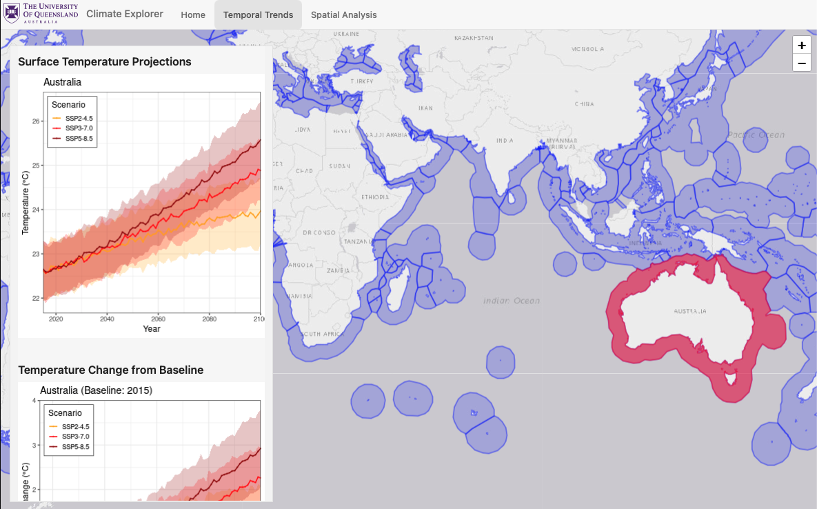
Climate change is rapidly undermining the effectiveness of traditional marine protected areas by shifting species distributions, disrupting ecosystems, and transforming ocean conditions. Despite this, most marine spatial planning (MSP) efforts still overlook climate change or treat it as an afterthought, risking misaligned conservation efforts and leaving marine ecosystems and dependent communities vulnerable. There is an urgent need to integrate climate foresight into planning frameworks to avoid wasting resources and to ensure biodiversity protection in the face of environmental change.
To address this gap, we are developing a suite of interactive, real-time web tools to embed climate change into the heart of MSP. The first phase involves The Climate Explorer App that lets users explore future ocean conditions under different emissions scenarios, visualise changes across key climate variables, and identify climate refugia and hotspots. Building on this, the second phase would deliver a biodiversity-climate risk app that applies a cutting-edge climate vulnerability index to assess species and habitat risk, guiding the design of climate-smart MPAs.
These open-source tools would empower planners—particularly in data-limited and island regions—to make informed, forward-looking decisions, helping countries meet biodiversity and climate targets while ensuring more resilient ocean stewardship.
Shiny App: Tuna spawning areas

The spawning of commercial tuna and billfish species represents a critical ecosystem service essential to global fisheries. Understanding where and when these species spawn is vital for effective management and conservation. We digitised a near-global larval dataset for 15 large pelagic fish species (mainly tuna and billfish) and leveraged machine learning techniques to develop comprehensive distribution models of spawning habitat. These models revealed consistent patterns in spawning timing and location across species, with many co-locating their spawning grounds—likely due to shared environmental benefits such as optimal conditions for larval survival and development.
The modelling showed distinct biogeographic patterns: tropical species spawn widely throughout the year across vast ocean regions, while temperate species exhibit more spatially and temporally restricted spawning behaviours. These insights have important implications for fisheries management and marine spatial planning, particularly for efforts aimed at protecting spawning grounds to ensure sustainable fish stocks. To make these research findings accessible and actionable, we developed an interactive Shiny App that allows fisheries managers, conservation practitioners, and researchers to interrogate the distribution models, explore spawning hotspots, and download data for their own analyses.
Shiny App: Oceanographic data analysis
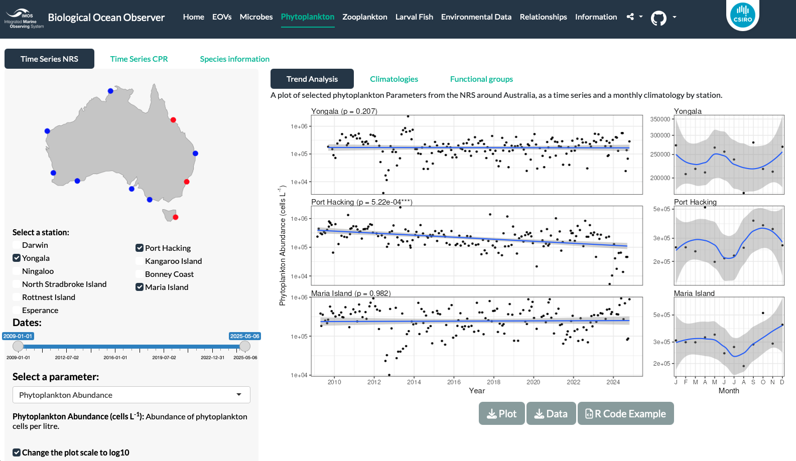
The Biological Ocean Observer is an interactive web platform that integrates, analyses, and visualises biological oceanographic data from the Integrated Marine Observing System (IMOS) platforms around Australia. This tool addresses a critical need in ocean observation: making complex, high-volume biological data accessible and interpretable to diverse user communities. The platform enables users to quickly explore temporal and seasonal trends across multiple biological groups, including phytoplankton, zooplankton, larval fish, and microbial communities.
By providing an intuitive interface for data exploration and analysis, the Biological Ocean Observer democratises access to Australia’s rich ocean monitoring datasets. Scientists can investigate ecological patterns, industry stakeholders can inform sustainable resource use, policy makers can make evidence-based decisions, and the public can better understand the state of Australia’s marine environment. The tool facilitates the translation of raw observational data into meaningful insights about ocean health, ecosystem function, and long-term environmental change—supporting informed stewardship of Australia’s ocean estate.
R package: spatialplanr
The spatialplanr R package is designed to streamline spatial conservation prioritization by providing easy access to key global datasets and simplifying complex planning workflows. Building upon the powerful prioritizr package, spatialplanr removes common barriers to effective conservation planning by offering convenient functions for accessing and processing essential data sources, including the World Database on Protected Areas (WDPA), IUCN Red List species data, and Global Fishing Watch fishing effort data. The package also provides tools for assigning conservation targets to spatial prioritizations, ensuring that planning efforts are grounded in best-practice conservation principles.
Beyond data access, spatialplanr offers functionality for incorporating climate considerations, connectivity analysis, and other advanced planning features into conservation workflows. The package helps planners design robust protected area networks by facilitating the integration of multiple data streams, from biodiversity distributions to human use patterns and environmental variables. While currently in active development, spatialplanr represents a significant step toward making comprehensive, data-driven spatial planning accessible to conservation practitioners worldwide.
R package: hotrstuff

The hotrstuff R package facilitates the rapid download, wrangling, and processing of Earth System Model (ESM) output from the Coupled Model Intercomparison Project Phase 6 (CMIP6). Climate projections from CMIP6 are essential for understanding future ocean conditions and designing climate-smart conservation strategies, yet accessing and processing this data has traditionally required specialized technical expertise and software. hotrstuff removes these barriers by leveraging the power of Climate Data Operators (CDO) within the R environment, making advanced climate data processing accessible to conservation practitioners and researchers.
The package streamlines complex climate data workflows with intuitive functions for downloading CMIP6 data, merging files, regridding to custom resolutions, slicing to specific timeframes, and changing temporal frequency (e.g., from monthly to yearly averages). It also enables calculation of vertical means for depth-resolved ESMs and creation of ensemble statistics across multiple models or scenarios. By simplifying access to state-of-the-art climate projections, hotrstuff empowers planners to incorporate robust climate information into conservation decisions—supporting the development of protected area networks that remain effective under future environmental conditions. While currently experimental, this tool represents a significant step toward democratizing climate data for conservation applications.
R package: minpatch
The minpatch R package implements the MinPatch algorithm for post-processing conservation planning solutions to ensure all protected areas meet user-defined minimum size thresholds. This addresses a critical practical constraint in protected area design: while optimization algorithms like prioritizr excel at identifying cost-effective solutions, they may produce fragmented patches that are too small to be ecologically viable or practically manageable.
Based on the methodology described in Smith et al. (2010), minpatch systematically adjusts conservation solutions by iteratively evaluating and modifying protected area patches until all meet specified minimum size requirements. This ensures that final protected area networks are not only optimized for biodiversity representation and cost-effectiveness, but also consist of patches large enough to support viable populations, facilitate management, and withstand edge effects. The package integrates seamlessly with prioritizr outputs, though it can work with any binary conservation solution raster. By bridging the gap between theoretical optimization and on-ground implementation constraints, minpatch helps deliver conservation plans that are both scientifically sound and practically feasible. Note that this package is still under active development.